
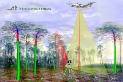
Treemetrics announces the release of its innovation in forestry technology, which combines both Terrestrial Laser Scanning (TLS) and Aerial Laser Scanning (ALS).
- Aerial Laser Scanning data provides information to describe quantity and height of trees
- Combining the two technology provides calibration data, and stem quality data
- Accurately shows foresters actual log products present, in each tree, and how they can change, depending on specification and quality
- Uses intelligent data, real-time analytics and simple-to-use web platform for harvest planning
Fill out the form below to request more information about Aerial and Ground-Based Laser Scanning
![[WEBINAR] Eliminating Integration Friction with a Single-Source 48V Power System](https://mindful-org-acbm.imgix.net/workspaces/default/uploads/2026/05/oem-ad-briggs-and-stratton-vanguard-ns-25983-1600x900-v1.SCpxqTXzuP.jpg?auto=compress%2Cformat&fit=crop&h=100&q=70&w=100)

![[WEBINAR] Eliminating Integration Friction with a Single-Source 48V Power System](https://mindful-org-acbm.imgix.net/workspaces/default/uploads/2026/05/oem-ad-briggs-and-stratton-vanguard-ns-25983-1600x900-v2.nSoFLhvSeL.jpg?auto=compress%2Cformat&fit=crop&h=100&q=70&w=100)
![[WEBINAR] Eliminating Integration Friction with a Single-Source 48V Power System](https://mindful-org-acbm.imgix.net/workspaces/default/uploads/2026/05/oem-ad-briggs-and-stratton-vanguard-ns-25983-1600x900-v1.SCpxqTXzuP.jpg?auto=compress%2Cformat&fit=crop&h=167&q=70&w=250)


