As part of a global initiative, Leica Geosystems Mining announced at MINExpo 2012 that the entire Leica Geosystems technology portfolio will be offered to the mining industry as a comprehensive Mining Solution.
Leveraging the broad scope of measurement solutions available from Leica Geosystems, Leica Geosystems Mining will present all pertinent technologies as part of its life of mine measurement solution.
As the mining business arm of Leica Geosystems, Switzerland, Leica Geosystems Mining has until now been primarily recognized as a provider of fleet management, production optimization and high precision guidance. There is, in fact, much more; Leica Geosystems Mining can offer a scope of technology that goes unmatched in the mining segment: technology that is proven, being used worldwide, and is immediately available.
They have also been in the space the longest – Leica Geosystems has been pioneering and developing measurement technology since 1819. With systems suitable for every aspect of the mine life cycle, the Leica Geosystems Mining Solution will provide one point of call for all measurement technology requirements – from exploration to remediation – be it slope monitoring, GNSS/TPS, survey, fleet management or machine guidance.
Integrated Slope Stability
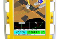
As a part of the Mining Solution, the Leica GeoMos software will be fully integrated with Leica Jmineops, the fleet management system that has made Leica Geosystems Mining a Tier One provider in the field. Pit slope stability alerts from the GeoMoS monitoring system will be routed in real-time to Jmineops.
Leica GeoMos is already the work horse on mines all over the world, monitoring and providing safety alerts for slope stability, integrity of overhead structures, profile displacements, settlements in tailing dams and more, sitting on the Leica Geosystems’ TPS and GNSS.
Each Leica GeoMos monitoring project will be fully visible along with all other Jmineops data, ensuring the highest level of safety through the precision and reliability of two outstanding and already proven technologies.
UAV
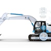
Also showcased alongside the GeoMos integration was an entirely new class of UAV (unmanned aerial vehicle) that is the result of a technology partnership between Leica Geosystems Mining and SwissDrones, a UAV developer. Safety in operation, quality of information gathered, payload capacity and flight time have been key KPIs in the UAV development process.
As a first, the Leica RCD30 medium format camera has been integrated into the SwissDrones Waran TC -1235 UAV. The Leica RCD30 is the world’s first medium format camera to provide superior multispectral imagery and the highest accuracy.
Unlike anything else on the market, even as a prototype, the UAV offers a level of functionality not yet seen. Specifically designed for the mining environment, the UAV can fly over pits and along walls (and wherever else required) for up to four hours via line-of-site remote control. In the near future, the unit will be fully automated.
“One of our key strengths is our focus on technology partnerships with experts in specific fields - like Locata, ASI and now SwissDrones,” states Haydn Roberts, CEO, Leica Geosystems Mining. “We will continue to build on our already extensive product portfolio via the adoption and development of new technology. Our strategic focus is to ensure that Leica Geosystems Mining maintains its place as the number one provider of life of measurement solutions.”
Global Reach, Local Support
The Leica Geosystems Mining Solution will be provided to the mining segment in direct partnership with the many global Leica Geosystems offices, accredited dealers and distributors, and industry partners. Via these channels, Leica Geosystems Mining has an unmatched reach and ability to provide their technology, service, partnership and support to clients at a local level, on a global scale.
Roberts states that by offering an extensive portfolio of measurement technologies and value added services, the Leica Geosystems Mining Solution would provide a cohesiveness to both multi-national and regionalized mining companies; resulting in measurable benefits across multiple operational streams for the entire mine life cycle.